


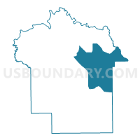
5I Pike Road Volunteer Fire Protection Authority, Montgomery County, Alabama
About
Outline

Summary
| Unique Area Identifier | 522710 |
| Name | 5I Pike Road Volunteer Fire Protection Authority |
| County | Montgomery County |
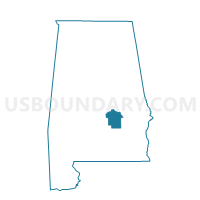
| State | Alabama |
| Area (square miles) | 108.65 |
| Land Area (square miles) | 107.90 |
| Water Area (square miles) | 0.75 |
| % of Land Area | 99.31 |
| % of Water Area | 0.69 |
| Latitude of the Internal Point | 32.25205460 |
| Longtitude of the Internal Point | -86.06113410 |
Maps

Graphs
Select a template below for downloading or customizing gragh for 5I Pike Road Volunteer Fire Protection Authority, Montgomery County, Alabama


Neighbors
Neighoring Voting District (by Name) Neighboring Voting District on the Map
- 5E Fitzpatrick Elementary School Voting District, Montgomery County, AL
- 5H South Montgomery Volunteer Fire Station, Montgomery County, AL
- 5J Georgia Washington Jr. High School Voting District, Montgomery County, AL
- 5L Saint James United Methodist Church, Montgomery County, AL
- 5M Bell Road YMCA Voting District, Montgomery County, AL
- Cornerstone, Bullock County, AL
- Fitzpatrick, Bullock County, AL
- Hardaway Volunteer Fire Station, Macon County, AL
- Old Prairie Farms Rec Center, Macon County, AL
Top 10 Neighboring County Subdivision (by Population) Neighboring County Subdivision on the Map
- Pike Road CCD, Montgomery County, AL (19,164)
- Mount Meigs CCD, Montgomery County, AL (8,677)
- Shorter-Hardaway CCD, Macon County, AL (2,309)
- Pine Level CCD, Montgomery County, AL (1,526)
- Fitzpatrick CCD, Bullock County, AL (750)
Top 10 Neighboring Place (by Population) Neighboring Place on the Map
Top 10 Neighboring Unified School District (by Population) Neighboring Unified School District on the Map
- Montgomery County School District, AL (226,849)
- Macon County School District, AL (21,452)
- Bullock County School District, AL (10,914)
Top 10 Neighboring State Legislative District Lower Chamber (by Population) Neighboring State Legislative District Lower Chamber on the Map
- State House District 75, AL (60,140)
- State House District 73, AL (48,266)
- State House District 76, AL (44,894)
- State House District 82, AL (43,389)
Top 10 Neighboring State Legislative District Upper Chamber (by Population) Neighboring State Legislative District Upper Chamber on the Map
- State Senate District 25, AL (157,932)
- State Senate District 28, AL (131,368)
- State Senate District 26, AL (120,666)
Top 10 Neighboring 111th Congressional District (by Population) Neighboring 111th Congressional District on the Map
Top 10 Neighboring Census Tract (by Population) Neighboring Census Tract on the Map
- Census Tract 56.07, Montgomery County, AL (4,531)
- Census Tract 55.03, Montgomery County, AL (3,722)
- Census Tract 56.04, Montgomery County, AL (3,533)
- Census Tract 56.11, Montgomery County, AL (3,140)
- Census Tract 9525, Bullock County, AL (2,378)
- Census Tract 2322, Macon County, AL (2,309)
- Census Tract 57, Montgomery County, AL (1,526)
- Census Tract 56.10, Montgomery County, AL (1,284)
- Census Tract 56.12, Montgomery County, AL (1,107)
- Census Tract 56.08, Montgomery County, AL (947)
Top 10 Neighboring 5-Digit ZIP Code Tabulation Area (by Population) Neighboring 5-Digit ZIP Code Tabulation Area on the Map
- 36117, AL (50,268)
- 36116, AL (43,790)
- 36064, AL (6,753)
- 36075, AL (2,226)
- 36069, AL (1,935)
- 36052, AL (739)
- 36029, AL (723)
- 36013, AL (562)